Site Evaluation: The Engineering Feasibility Siting Factor
by Alex Cordiner, Principal Engineering Manager at Nuclear Waste Services
Site Evaluation
Site Evaluation is a crucial step in the journey toward identifying a suitable location for a Geological Disposal Facility (GDF). It informs the Site Suitability Perspective – one of three key perspectives in the Decision Making Framework that guides Nuclear Waste Services (NWS) in key siting decisions including deciding which communities may progress to deep borehole investigations.
Through detailed studies based on the Six Siting Factors and 26 Evaluation Considerations in the Site Suitability Perspective, NWS assesses whether a GDF can be designed, constructed, operated, and closed safely.
Engineering Feasibility Siting Factor
One of the Six Siting Factors is the Engineering Feasibility Siting Factor. This works together with the Safety and Security Siting Factors to evaluate the likelihood of safely investigating, designing, constructing, operating, and eventually closing a Geological Disposal Facility (GDF) within the Search Areas and the inshore area in the deep geology beyond the coast.
Our work forms part of the Site Suitability Perspective, which will inform NWS’ decision on which communities should be taken forward to more detailed Site Characterisation. This will include activities such as deep borehole investigations to build a clearer understanding of the local geology, as well as research into how engineered systems could work in that geology. This will ensure that the waste is isolated and contained, keeping people and the surface environment safe and secure over the hundreds of thousands of years it will take for the radioactivity to naturally decay.
We also examine how flexible each location is in supporting the delivery of a GDF. This includes identifying potential design options, assessing environmental implications (see Environment Siting Factor), developing transport requirements (see Transport Siting Factor) and producing cost and schedule estimates to understand value for money.
Importantly, our assessments consider whether a GDF could safely accommodate both current and future radioactive waste packages, in line with waste producers’ current plans (see Waste Inventory for Geological Disposal).
Finally, we identify knowledge gaps that need to be addressed through future Site Characterisation activities and through a dedicated programme of Research, Development, and Demonstration.
What are the initial feasibility studies you are carrying out?
We have identified smaller Areas of Focus within the Search Areas and the inshore area beyond the coast to guide the Site Evaluation studies and help prioritise resources for assessing the potential of each area to safely host a GDF.
We are evaluating seven key Engineering Feasibility considerations:
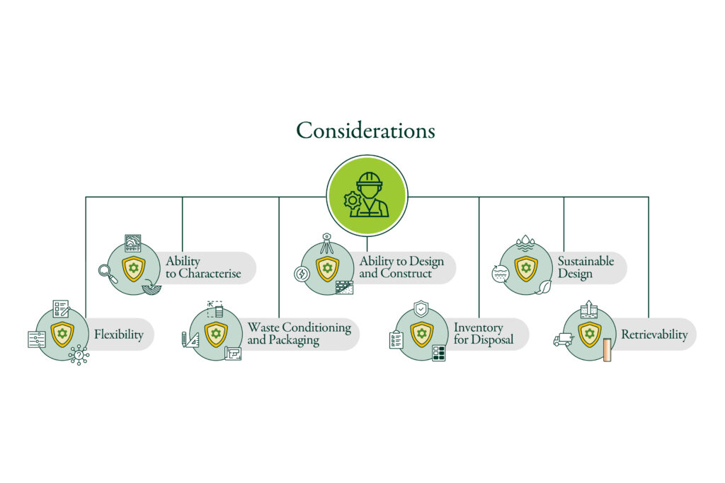
- Ability to Characterise: The ability to characterise (investigate and understand) within the constraints of the area.
- Ability to Design and Construct: The ability to design and construct a GDF within the constraints of the area.
- Inventory for disposal: The ability to design, construct and operate a GDF such that the waste inventory can be disposed.
- Flexibility: The ability to apply a variety of design solutions to a given area.
- Sustainable design: The ability to design, construct and operate a GDF in a sustainable manner.
- Waste Conditioning and Packaging: The ability for waste that is already or still to be packaged to be accepted at a potential area.
- Retrievability: The ability to design, construct and operate a GDF so that, if there was a compelling reason to do so, waste could be retrieved during the operational phase.
Our studies are structured around the three distinct Areas of Focus:
1. Surface (the facilities and infrastructure above ground);
2. Sub-surface (the underground disposal areas within the host rock), and
3. Accessways (the connections between surface and sub-surface facilities).
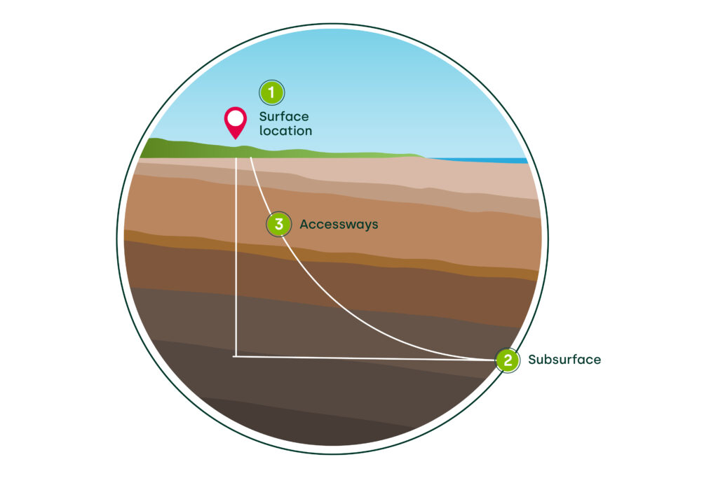
By examining Areas of Focus, we can consider the long-term engineering feasibility of a GDF at specific locations and evaluate whether they could be suitable.
We are also identifying a set of information needs – the knowledge required to progress the design of the Surface, Sub-surface, and Accessways. Meeting these information needs will involve approximately 10 years of Site Characterisation and supporting research, which will inform the development of the GDF design and the eventual Safety Case – evidence that the facility can safely contain and isolate radioactive waste from humans and the environment both during its operational life and for hundreds of thousands of years after closure.
Sub-surface Disposal Areas
We are starting to evaluate whether it’s possible to design an engineered barrier system that can work together with the geology to safely contain radioactive waste and protect people and the environment.
To do this, we are:
- Identifying the safety and performance requirements that the engineered barrier system must meet to securely dispose of the radioactive waste in different types of host rock.
- Exploring possible materials, designs, layouts and waste emplacement methods that would meet these requirements.
We are also evaluating whether it would be feasible to build the underground disposal areas in the candidate host rocks by looking at:
- The size of the underground excavations which could be created.
- The support structures needed to keep these excavations stable for the required time.
- The construction methods and techniques that could be used to build the underground areas safely and efficiently.
We are also assessing the volume and location of potentially suitable host rock, compared against the estimated volume required to dispose of the waste inventory for geological disposal.
Surface Facilities
To begin investigating whether a GDF surface site could feasibly be developed within a given Surface Area of Focus, we are looking at the following:
Surface Masterplanning:
- The surface-based facilities required to construct and operate a GDF.
This will enable NWS to evaluate whether enough land is likely to be available within the Areas of Focus, and the flexibility of that land, to build and operate the required surface facilities.
Excavated Material Management:
- Estimate the types and volumes of excavated material that will be generated through construction of the surface facilities, accessways and underground disposal areas, and the properties of these materials.
- Assess excavated material management options, including re-use options. This article How will excavated material be managed in a GDF? provides further information on NWS’ approach to excavated material.
Flood Risk and Coastal Erosion:
- Assess the current flood risk and future coastal change and how it may evolve over the operational lifetime of a GDF.
- Identify whether flood protection measures are likely to be required to protect a GDF surface site and, if they are, potential protection strategies.
Water Cycle
- Estimate the water demand and how this would be managed within a given location.
- Assess how groundwater encountered during construction and how surface water (e.g. rainfall on the surface site) could be managed.
- Identify potential options for the management of wastewater.
Power Utilities
- Estimate the power demand and requirements for the construction and operation of a GDF.
- Investigate whether sufficient power can be supplied to the site using existing infrastructure and, if not, the infrastructure upgrades required to service a GDF.
Accessways
To start to evaluate whether it is feasible to construct, operate and close the accessways, we are assessing the following:
- Ground conditions: The ground condition which we expect to encounter during accessways construction and the potential challenges which will need to be managed throughout the lifetime of the accessways.
- Accessways construction techniques: Techniques that could be used to construct the accessways safely, responding to the expected ground conditions.
- Accessways design options: Design options which deliver the functionality required to safely and effectively operate a GDF within the expected ground conditions.
- Accessway sealing: The ability to seal the accessways once all the waste has been disposed of, ensuring that it remains isolated from people and the surface environment.
What are the next steps once these studies are complete?
We will have a phased and extensive design programme to robustly evaluate the full range of options for developing a GDF and to establish site-specific designs.
So far, our studies have been predominantly desk-based, drawing on existing legacy data, as well as the Marine Geophysical Survey completed in 2022.
Initial assessments in Copeland have indicated potentially suitable geology, but we need to investigate further to confirm this. The video Understanding Copeland Geology looks at NWS’ ongoing work to develop geological understanding.
We know the Sub-surface Area of Focus in Copeland contains a large volume of geology called the Mercia Mudstone Group (MMG) – a large and geologically complex formation made up of mudstones and halite (rock salt). Both rock types are known for their very low permeability, which means water cannot easily move through them. This property is extremely important, because it helps ensure that waste remains safely contained away from the surface environment. The MMG also extends to significant depths, providing physical separation to isolate waste from people and the environment.
Site Characterisation would involve drilling boreholes to better understand the rock types and ground conditions where the GDF could be built and help reduce Engineering Feasibility uncertainties. The results of this Site Characterisation work will enable NWS to make informed decisions about the preferred location for a GDF.